


Top 5 Hiking Trails in South Sweden

Skåne, Sweden’s southern gem, is a region that never ceases to amaze. From the enchanting landscapes that stretch from dense forests to breathtaking coastal views, this captivating destination promises a diverse and unforgettable outdoor adventure. Whether you’re an experienced hiker or just looking for a casual stroll through nature, Skåne offers a wealth of trails that cater to all levels of hikers. In this blog, we will embark on an exciting adventure through the top 5 hiking trails that Skåne has to offer, each with its own unique charm and character.
Why We Love It
Skåne has a special place in the hearts of those who seek the serenity and wonder of the great outdoors.Here is why we love Skåne:
Beautiful Nature: Skåne boasts some of Sweden’s most beautiful and unspoiled landscapes. From dense, enchanting forests to breathtaking coastal vistas, the region’s natural beauty is a sight to behold. The charm of Skåne’s nature is truly boundless. You can seamlessly transition from flat stretches to hilly sections, exploring green valleys and meandering through ancient forests. Whether you’re drawn to the coastal landscapes or the serene beauty of Skåne’s lakes, you’ll find a world of contrast within a this part of Sweden. But Skåne’s hiking trails are not just about natural beauty. They are a journey through history as well. These trails often pass through historic sites, adding a cultural layer to your outdoor adventure. Explore citadels, ancient churches, and traces of battles that have left their mark on the land.
Interesting Facts About Skåne
Skåne is not just a land of scenic wonder. It is also steeped in interesting facts and cultural significance. Skåne has a unique cultural identity, distinct from the rest of Sweden. You’ll notice this in everything from the local dialect to the cuisine. The region’s history, which includes periods of Danish rule, has left an indelible mark on its character. Skåne is known for its blooming rapeseed fields that paint the landscape a brilliant yellow during spring. The sight is nothing short of spectacular and attracts visitors from everywhere.
Interesting Facts About the Skåneladen Trails
Skåneladen trails, part of the Skåneleden trail system, have their own unique tales to tell. The Skåneladen trails form an extensive network of paths and routes, covering a significant portion of Skåne. In fact, there are about 1250 kilometres of marked hiking trails in Skåne, called Skåneladen trails or abbreviated as SL1, SL2, Sl3, SL4, SL5.
- SL1 Kust till Kust (Coast to Coast)
- SL2 Nord till Syd (North to South)
- SL3 Ås till Ås (Ridge to Ridge)
- SL4 Österlen
- SL5 Öresund
These trails are carefully designed to showcase the region’s diverse landscapes, making them perfect for both avid hikers and casual strollers. Skåneladen trails are well-marked with orange markings. These markers guide you along the way, ensuring you don’t lose your path as you traverse through the region’s varying terrains.
What Is the Difficulty of the Trails
Skåneladen trails cater to a wide range of hikers, from beginners to experienced trekkers. The difficulty of the trails varies, ensuring that there’s something for everyone. You can choose from easy, moderate, and slightly challenging routes, allowing you to tailor your hiking experience to your skill level and preferences. Many of the trails can be reached via public transport, thanks to Sweden’s well-developed railway network and frequent bus services. Some hikes are accessible by car, making it convenient for those with their own vehicles.
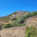
As we delve further down in the blog post into the specifics of the top 5 hiking trails in Skåne, you’ll find that each trail offers a unique experience, from coastal adventures to encounters with historic landmarks and the pristine beauty of nature. Additionally, Skåne boasts numerous other hiking areas that are not necessarily part of the Skåneladen trails but are worth exploring! These include but are not limited to Kullaberg, Sövde Lake, Lomma Beach, Dalby Söderskog, Dalby Norreskog, Sövde Mosaik, and Vombsjön Lake, ensuring there’s a trail for every adventurer’s taste.
Now let’s dive into the top 5 hiking trails we recommend exploring while in Skåne.

- Trail (SL5): Point to Point (2 stages included in this suggested hike)
- Starting point: Helsingborg, regular buses and trains available
- Ending point: Landskrona, regular buses and trains available
- Length: 30 km
- Duration: 6.5 hours
- Difficulty: Intermediate
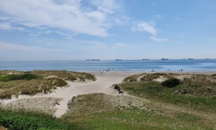
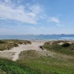
1. Helsingborg to Landskrona Coastal Hike
Nice to Know
This hike is part of SL5 trail and we recommend hiking along stage 7 (Helsingborg to Rydebäck, 16 km, which has an easy level of difficulty) and stage 8 (Rydebäck to Landskrona, 13 km, with an average level of difficulty). However, it’s worth noting that stage 8 is a personal favorite due to its captivating coastal route, offering breathtaking seaside views. In contrast, stage 7 leans more towards an urban hike, providing an opportunity for exploring Helsingborg surroundings. So, while both stages have their own charm, don’t miss the opportunity to be mesmerized by the coastal beauty on stage 8. Also, consider the fact that doing both stages in one day may require higher physical efforts.
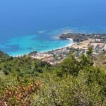
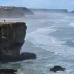
Generally, the SL5 trail spans the impressive 214 kilometers. This extensive trail, which can be tackled in multiple sections, takes hikers from Utvälinge in the north to Trelleborg in the south, forming also a circular route around the Falsterbonäset Peninsula. As you explore the SL5 trail, you’ll be treated to an array of stunning views. Along the way, you can relish magnificent sea views that stretch as far as the eye can see. History enthusiasts will revel in the fact that this trail passes through places with rich historical backgrounds. For example, in this suggested stretch of SL5, you will pass through Helsingborg, with its iconic Kärnan and the Church of St. Mary, showcasing the region’s heritage, while Landskrona boasts the impressive Landskrona Citadel. And don’t forget the charming villages along the way, such as Glumslöv and Rydebäck, which add a touch of local color to your hike.
As you journey along the Helsingborg to Landskrona trail, be sure to keep an eye out for the enchanting island of Ven. This picturesque island becomes visible as you walk along the coastline, adding an extra layer of beauty to your hiking experience. One particularly fascinating fact about Ven is its connection to the renowned astronomer Tycho Brahe. In the late 16th century, Tycho Brahe constructed two observatories on the island, Uraniborg and Stjerneborg, to observe the heavens. His groundbreaking astronomical work on Ven contributed significantly to our understanding of the universe and laid the foundation for modern astronomy.
How to Get There
Hop on a train to Helsingborg or Glumslövs train station for a shorter route. There is of course options to reach the starting points with car. If you’re looking for a less challenging experience, consider starting your journey at these coastal villages, allowing you to relish the breathtaking coastline right from the outset.
When to Visit
Anytime, but best enjoyed on calm, wind-free days.
Read more about the hike here (map included)!

- Trail: Loop
- Starting point: Röstånga (see below how to get to Röstånga)
- Ending point: Röstånga
- Length: 21 km
- Duration: 5 hours
- Difficulty: Intermediate
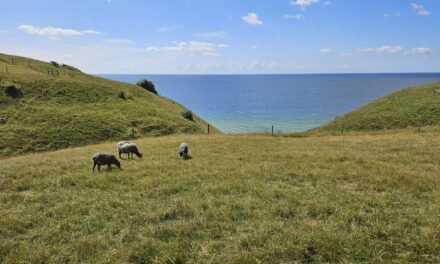
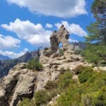
2. Söderåsen National Park
Nice to Know
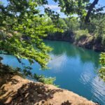
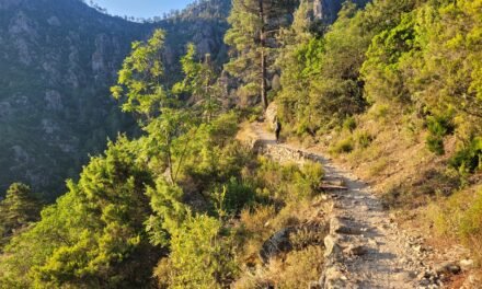
Söderåsen National Parkis a natural wonder that was officially established in 2001. What distinguishes it from other parks are its remarkably varied landscapes, which encompass everything from lush forests to towering cliffs, meandering river, and sweeping panoramic views. One of the highlights of the park is Kopparhatten, which offers a breathtaking view over the valley and is often referred to as Skåne’s Grand Canyon. The landscape here is nothing short of dramatic, featuring deep ravines up to 90 meters in depth. What’s more, you can reach the summit of Kopparhatten effortlessly, as there is parking spaces for cars. Within the Söderåsen National Park is the Odensjön (Odin’s Lake). This lake, perfectly round and steeped in myth, is named after Odin, the Norse God associated with various aspects of life. Legends surrounding the lake are diverse. One of the legends is rooted in its name. The lake’s name is said to be linked to Odin’s one eye, as he sacrificed an eye at Mímir’s well in pursuit of wisdom. Some tales suggest that Odin’s eye, symbolizing his divine knowledge, is believed to be hidden within the depths of the lake, granting those who dare to seek it with heightened wisdom and understanding. Another legend associated with Odin Lake is the mystery of its formation. Some locals believe that the lake has an otherworldly origin, and its creation cannot be attributed to natural forces alone. It is said to be bottomless, giving rise to stories of hidden treasures and ancient secrets inside the waters. While the mystery persists, the lake’s depth has been measured at 19 meters.
Apart from the lake, the trails within the park offer a delightful blend of wide paths for two, narrow single-person tracks, and a landscape that continuously evolves. You’ll meander through hills, flat stretches, and winding trails. Keep an eye out for the unique sight of tinder fungus, adorning the trees and paths along your journey. And the adventure doesn’t end with hiking. Within the park, you can embark on a moose safari, visit a charming goat farm, and enjoy moments of relaxation. Moreover, there are opportunities to explore the surrounding areas, each offering its own unique landscape. You can continue exploring the surrounding area in the park and climb to higher vantage points, taking in breathtaking cliffs and the Skärån river below. Enveloped by vibrant forests, you’ll also encounter tranquil picnic spots near the Skärdammen Pond, which was created as a backdrop for a former hotel (now replaced by a red, wooden visitor centre).
How to Get There
If you are planning your trip by car, then you can arrived at the main entrance located in Skäralid, where you’ll find hiking information boards and the Naturum Visitor Centre. Alternatively, you can access Söderåsen National Park through the second entrance in Röstånga. Here, the local tourist office can provide you with maps and additional information to enhance your park experience. The entrance in Röstånga is also accesible by public transport. We started our journey from Copenhagen or Malmö with a train to Eslöv. Once you’ve arrived in Eslöv, board a train bound for Stehag. From Stehag, you’ll catch a bus that will take you directly to Röstånga, the gateway to Söderåsen. Bus Number 518 is your ideal mode of transport, as it conveniently stops at both the park’s main entrance in Skäralid and the second entrance in Röstånga.
When to Visit
Year-round beauty, but book your moose safari adventure in advance if you include it in your plans.
Read more about the hike here (map included)!

- Suggested Trail: Loop
- Starting point: Simlängsdalen, busses available
- Ending point: Simlängsdalen, busses available
- Length: 17 km
- Duration: 4.5 hours
- Difficulty: Intermediate
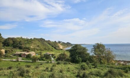
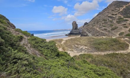
3. Danska Fallen
Nice to Know
Danska Fallen Naturreservat is a hidden gem located near the charming littlw town of Simlångsdalen. Wandering through Danska Fallen nature reserve, you’ll find yourself surrounded by century-old trees, undisturbed by human intervention for many years. However, what truly sets Danska Fallen apart is the remarkable waterfall, Danska Fall, cascading from a height of 36 meters. This natural wonder is located just upstream from Lake Brearedssjön and is nestled within a narrow gorge with steep rock walls, creating a small canyon-like setting. The waterfall itself is surrounded by stories and legends, adding a touch of intrigue to your hike. The name “Danska Fall” is derived from a historical tale that dates back to 1676, during the Scandinavian War. After a devastating defeat in the Battle of Fyllebro near Halmstad, a scattered group of Danish soldiers sought refuge in the forest near Simlångsdalen. Pursued by a Swedish unit, they attempted to cross a rickety bridge spanning the waterfall. Tragically, the bridge collapsed under their weight, leading to the loss of several Danish lives in the turbulent waters below.
Expanding your adventure, you have the option to make a more extensive circular hike around the lakes of Simlångsdalen and Fulleån. Along the way, you can traverse other natural parks such as Hule nationalpark, Broda nationalpart, Veka (södra), Veka naturreservat, Hule naturreservat, and optionally extend your journey to Lillared-Klövabergets naturreservat.
How to Get There
Reaching the mesmerizing Danska Fallen is a journey that combines convenience with the allure of nature. You can drive to Danska Fallen and find a parking lot conveniently located near the trailhead. This option allows you the flexibility to explore the area at your own pace. Alternatively, you can opt for public transportation. You may for example start your journey by taking a bus from Halmstad to Simlångsdalen. Upon arriving in Simlångsdalen, the trail to Danska Fallen begins right from the bus stop. From here, you’ll head toward the lake and cross a picturesque bridge over the river.
When to Visit
Enjoy Danska Fallen and the other natural parks in any season.
Read more about the hike here (map included)!

- Trail (SL3): Point to Point (2 stages included in this suggested hike)
- Starting point: Höör Station; regular trains and busses available
- Ending point: Ekeröd, busses available
- Length: 23 km
- Duration: 6 hours
- Difficulty: Intermediate
4. Bjeveröd
Nice to Know
Bjeveröd, a hidden gem in Skåne, is an area brimming with natural beauty and distinct characteristics that make it an unforgettable hiking destination. Bjeveröd is part of the SL3 trail and is a starting and ending point of stage 10 and stage 9, respectively. Stage 9 covers the 11-kilometer stretch from Höör to Bjeveröd. This leg of the journey is considered to be of easy difficulty, perfect for hikers seeking a leisurely yet scenic experience. Stage 10 extends from Bjeveröd to Ekeröd, spanning 12 kilometers with a moderate level of difficulty. This stage adds a touch of challenge. It’s worth noting that stage 9 of the SL3 trail coincides with stage 8 of the SL2 Trail, which traverses north to south in Skåne. The SL3 Trail, known as the “Ridge to Ridge Trail,” is a hiking route that spans from Åstorp at the base of Söderåsen ridge to the Brösarp hills in Österlen, Skåne’s northeast. It covers substantial 162 kilometers and comprises 15 sections.
If you are starting at the serene Bjeveröd pond, where you may encounter local fishermen, you’ll really want to walk across the scenic wooden planked bridge. If you decide to divert your route from the bridge, the path may lead you to a completely different landscape, where you’ll tread on a narrow trail adorned with rocks, branches, and gnarly roots. This part of the trail feels like an uncharted wilderness. If you continue towards Ekeröd, the SL3 trail will lead you through ever-changing terrains. It meanders through various landscapes, with wooden bridges, narrow pathways, beech and pine forests, and even the occasional obstacle of fallen trees. Along the way, you’ll face thrilling challenges, including steep inclines and stretches through meadows with little shade.
How to Get There
Bjeveröd is accessible via multiple transportation option. If you prefer the flexibility and convenience of traveling by car, you can drive to Bjeveröd. There is a parking area located in close proximity to the meadow. However, it’s important to consider that if you’re planning to hike from Bjeveröd to Ekeröd, you’ll need to make arrangements for your return to the parking area, which may add to your overall hiking distance. For those who are up for a unique challenge and wish to extend their hiking experience, consider walking to Bjeveröd from nearby areas. One option is to start your hike from Höör, which can be easily reached by train, particularly if you’re traveling from Malmö. Once you’ve enjoyed your hike from Höör to Bjeveröd, you can continue on to Ekeröd. Additionally, for the return journey or further exploration, buses from Ekeröd to Malmö operate on a somewhat regular basis.
When to Visit
Every season paints a unique picture of the landscape.
Read more about the hike here (map included)!

- Trail (SL2): Point-to-point
- Starting point: Höör, trains and buses available
- Ending point: Höör, trains and buses available
- Length: 25 km
- Duration: 5.5 hours
- Difficulty: Intermediate
5. Frostavallen
Nice to Know
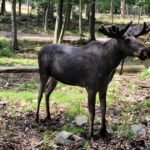
The Frostavallen area, located near Höör and part of the SL2 Trail North to South offers an enriching outdoor adventure amidst Skåne’s natural beauty. The SL2 trail starts from Hårsjö (just west of Vittsjö) in the north all the way down to the coastal city of Trelleborg in the south. The trail is characterized by dense woodlands, open savannah-like environments, and stunning country estates. The trail has 34 sections and is 325 km in length. Stage 8 of the trail starts from Höör to Bjeverod and overlaps with stage 9 of SL3 trail. That section of the trail is quite interesting as you may discover ruins and memorial stones. The hike is accompanied by the soothing sounds of water springs and you will likely traverse past Vaxsjön lake. But the most interesting part of the hike is likely to be the Skånes Djurpark (zoo park). Here, you’ll have the chance to see brown bears, seals, wolves, deer, lynx, wolverines, and even cute little animals like goats and pigs. In the Frostavallen hiking area, which dates back to the 1930s, you’ll encounter old volcanoes, species-rich beech forests, and open fields. These elements contribute to a captivating natural landscape. For those craving more adventure, venture northward toward Dagstorpssjön, a scenic lake offering various water activities, camping spots, and leisurely walks amidst the enchanting forest surroundings. The hike encompasses several parks, including Bjäret, Ekastiga, and Frostavallen – Ullstorp.
How to Get There
If you’re primarily interested in exploring the zoo, you can conveniently park your car at Skånes Djurpark. However, remember to buy your tickets in advance to ensure a hassle-free visit. Alternatively, if you’re planning to embark on a hiking adventure from Höör, you’ll find that it’s within walking distance from the train station. The journey to Höör by train is straightforward, especially if you’re traveling from Malmö or neighboring areas.
When to Visit
The lakes’ views are worth seeing year-round. Remeber to plan and book tickets for the zoo park.
Read more about the hike here (map included)!
Skåne, Sweden’s hidden gem, offers a diverse and captivating landscape for hikers of all levels. Beyond the Skåneladen trails, Skåne beckons with countless hidden gems, from the legends of Odin’s Lake to the mystique of Danska Fallen. When planning your adventure, take advantage of Skåne’s excellent accessibility options, including public transport and well-maintained roads. So, pack your gear and embark on your Skåne adventure. Happy hiking!


0 Comments
Trackbacks/Pingbacks